Keep Hwy 50
four lanes
What’s the plan? Road Diets and Bike Lanes — The NDOT / TRPA Corridor Management Plan.
KEEP hwy 50 four LANES – What’s the Plan?
Road Diets and Bike Lanes, The NDOT / TRPA Corridor Management Plan
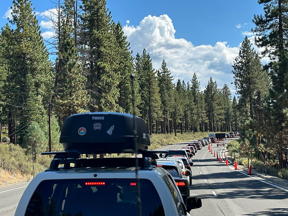
NDOT’s plan to remove two of four lanes of Hwy 50’s east shore corridor was first rolled out in 2017. When 200+ residents showed up to protest, NDOT retreated to Carson City. In ’22 they returned to the Lake with the same basic Corridor Management Plan 2.0 to reduce large sections of the 13-mile corridor from Stateline to Spooner Summit to two lanes with a center turning lane, sometimes referred to as a suicide lane for the dangers posed by drivers misusing the lane to circumvent traffic gridlock. In traffic vernacular, this is called a road diet.
“Traffic calming essentially calls for worse-designed roads to force people to slow down. This will increase accidents. For every pedestrian whose life is saved by traffic calming, more than thirty people will die due to delays to emergency service vehicles.”
~Fire Dept, Austin, TX
Where does the bike lane fit in?
The hidden-in-plain-sight subtext of this radical reconfiguration is the drive to add a bike lane – or more precisely a bimodal path for bicycles, wheelchairs and other favored forms of transit. This agenda is being advanced in lockstep by TRPA, regional cyclist organizations, and other groups/agencies around the Lake who are determined to insert their bike lane into the “new and improved” US 50 East Shore road system as a way of attracting more bike tourism to the basin. And more funding.
“Most auto-bicycle accidents happen at intersections, not from cyclists being hit by cars moving in the same direction as the bicycle. Yet, inflamed by an anti-auto mentality, bicycle proponents have focused their efforts on penalizing auto drivers and diverting auto lanes of travel to exclusive bike lanes.”
~John Forester, Vehicular Cycling Advocate
Where is the mandate for this radical reconfiguration coming from?
With millions of federal dollars at stake and increased federal and state pressure toward road-diets, community connectivity and bimodal transportation, this is a high stakes gambit to reimagine the only viable emergency evacuation corridor for south/east shore communities in order to accommodate more progressive transit concepts and ideologies. This is where the rubber meets the asphalt road. Will such self-indulgent ideologies take precedence over more practical considerations like fire evacuation?
“Traffic calming essentially calls for worse-designed roads to force people to slow down. This will increase accidents.”
“For every pedestrian whose life is saved by traffic calming, more than thirty people will die due to delays to emergency service vehicles.” ~Fire Dept, Austin, TX
What about evacuation?
 In the face of increasingly intense and destructive fire patterns, including Camp/Paradise, Dixie, August Complex and more, new requirements of roadway-by-roadway evacuation capacity evaluations to be conducted prior to agency approvals of new building or road construction projects have been largely ignored by TRPA and other agencies. Despite grand jury recommendations, California AG guidelines, and CEQA requirements, new projects get rubber stamped and put through with little or no evaluation of impacts on environment, evacuation routes and plans.
“Evacuation in Caldor worked fine north of Stateline.” ~Darin Tedford
“Not only does road diet impede evacuation but also the ability for first responders to reach the scene. It’s a lose-lose.” ~Lake Tahoe resident
Has the hwy 50 East Shore Corridor been properly evaluated for evacuation capacity?
No. No systematic evaluation using state of the art modeling tools and technology has been used to assess existing or proposed US 50 configurations. Caldor was a wakeup call—evacuation plans and infrastructure did not function well. In fact one fire official has said, It was a disaster! And Caldor was not a worst case scenario. Yet NDOT insists that “evacuation worked just fine north of Stateline.” With fire risk at an all time high and 750,000 burn piles stacked around the Basin, we are not well situated to handle the non-virtual evacuation of many thousands of residents and visitors in a wildfire event.
“Even before the fire we wondered what the hell they were thinking.” ~Paradise resident
The Choice?
NDOT is not offering a choice. But we the people must demand the option to preserve the only evacuation route we have in the event of wildfire. Safety improvements can and should be made on US 50 that address root causes and not red herrings: speed monitors, better signage, law enforcement, traffic lights. In the final analysis, we believe the risks of inadequate evacuation far outweigh the benefits of a bi-modal bike path.
East Shore residents have been asking NDOT for serious modeling and simulation to demonstrate safety benefits of CMP. Here is their response.
care to comment
What are your thoughts on the NDOT/TRPA plans for a road diet on US HWY 50?
Road diets create the illusion of safety, without actual safety. ~Randal O'Toole, Thoreau Institute
road diet gimmicks?
not going to work here
Our goal is to protect our Lake and forests, highways and communities from ill-conceived plans by a few urban planners and bureaucrats who aim to recreate the Tahoe basin in their own image. The future of our basin depends on residents who will stand up, speak up and hold the line before it’s too late.
Our first priority is the preservation and safety of the 4-lane US 50 corridor which serves the larger South Lake Tahoe and East Shore communities as the only viable emergency evacuation route in the event of wildfire. NDOT’s Corridor Management Plan 2.0, which threatens to remove 2 of 4 traffic lanes in favor of a bike path, is back on the table despite fervent and consistent opposition from residents.
The Caldor Fire was a wake-up call to all of us. The evacuation was chaotic despite a 4-lane US 50.Imagine that evacuation scenario with only 2 lanes.
Bottom line: We need an effective fire evacuation corridor more than we need a road-diet or bi-modal bike path.
Join our efforts to ensure that US 50 improvements and modifications enhance basic transit safety, traffic flow and evacuation capacity for visitors and residents along our East Shore and Tahoe basin communities.
Residents go to war over road diet havoc
The problem in less than 5 minutes
Let's do it!
tesa roar
restore
optimize
advance
revive
reclaim
Reclaim our communities and stewardship responsibility from unelected officials more interested in money and power than the well-being of Lake, the basin and its residents.
optimize
Optimize road safety, mobility and evacuation capacity.

Activate tesa
Activate TESA public database for truth, information and transparency in local planning and governance.
ADVANCE
Advance the voice, authority and standing of residents to determine what is best for our Lake and community.
Restore
Restore integrity and sanity to development and preservation efforts in the basin.
reverse
Reverse the spiral of environmental degradation and collapse.
Revive
Revive the essence of all that makes Tahoe unique, special and a national treasure.

In 2017 NDOT came to the community held a meeting at Zephyr Cove school. They expected a small crowd. Over 200 people showed up passionately against this project. NDOT went away for five years and came back with essentially the same plan. They didn’t have any public meetings. They obfuscated the public comment by having people put Post-it notes around the room so can say whatever they want the public comment to be. It was a mess.
The traffic flow studies upon which the CMP study team relied are averages and do not capture the real congestion problems that residents and visitors face under Peak flow conditions this can only be established through comprehensive collection of peak traffic volume speed and Transit time data. NDOT is now proposing to shut down two lanes of traffic for a demonstration project to allow NDOT to gather important data points such as average speeds crash data rates and performance of merged Verge points. again that word average in my view this is a major oversight and downplays the real issue along the corridor which is congestion during rush hours and over weekends and holidays during the high seasons.
NDOT ran a Statewide study back in 2016 asking residents what they wanted most out of their highways. Do you know that the number one answer was? Operational efficiency. Imagine, Nevada tax paying citizens want to be able to move on the roads that you built. Do you know how many Nevada citizens want a bike path? 16 percent . I am asking you the board one more time to please listen to the people in the state.
Traffic is projected to increase as it has for decades along the CMP corridor and NDOT wants to shrink it--this doesn’t make sense. The data case studies and road shrinkages that NDOT has cited in support of its campaign are almost all inapplicable to Highway 50. And the claim that road shrinkage will reduce travel time by only 2 minutes from Spooner Summit to Stateline is not credible. Operation in winter will be horrible. What do you think is going to happen then? Highway 50 is defined as a principal arterial. Reducing the width and number of lanes and enforcing multiple merging traffic patterns will harm the interests of residents, commuters, business people truckers and public safety personnel.
After delaying your plans last December to make the changes to our 13-mile stretch, you promised you would return first to the Douglas County Board of Commissioners and most importantly to us as residents regarding lane reductions. Those promises were not honored… We want to improve safety but very few of us embrace the lane reductions you continue to propose. We want turn Lanes, we want lights if needed, roundabouts and elimination of on-road parking, decreased speed limits signage, Illuminating current speed and increased law enforcement presence--not reducing the lanes which compromises our travel.
Does anybody recall the previous generation’s long fight to make US 50 a four-lane? The previous generation is still alive and although they’re not here they’re in their 80s most of them they remember a time when that was two lanes and they fought so hard with far less traffic to make this a four-lane highway. This lane reduction affects tourism for our business, it affects tourists because they won’t want to come to Lake Tahoe and sit in a bottleneck every single holiday.
Does NDOT US 50 East Shore management plan address snow removal operations adequately? Winter weather put the highway in a challenging position. I don’t understand how the plow teams will move the snow off the road if lanes are removed and how so many visitors, supply trucks and locals can rely on this highway to move.
I’m a road cyclist. I love riding but I do not support the proposal. If the purpose of reducing lanes on 50 is to reduce crashes from cyclist and car interactions there are better proposals.
I was in the third graduating class of George Whittell High School. In 1963 when traffic conditions warranted widening that road to 4 lanes, we were so happy. It is ridiculous to even talk about narrowing this road now. I am a 34-year veteran from the Tahoe Douglas Fire Protection District. Those hundred accidents that they say happen in that area each year, about a third of them are in Zephyr Cove, mostly due to the parking on the highway, people that are under the influence trying to get into their cars and walking down the middle of the highway. Stop the parking on the highway and clean up Zephyr Cove.
Through terrible weather and long tourist seasons, we all suffer the same problems of overcrowded roads. The thought of making them smaller makes our employees who travel from the valley very frightened to drive up and down our roads. How are we going to get people to work in Lake Tahoe with only one lane?
I want to remind you that, courtesy of the Tahoe fund non-profit, Douglas County has a sawmill and logging trucks now graze Highway 50 from South Lake Tahoe down to Carson City for further conflict on the roadway. And that logging Mill is going to be there for many many years. I hope you are listening to the public as well as the business owners at this is a very critical juncture in the future of what the East Shore Corridor is going to look like.
Please do not restrict our mobility on our roadways. There's other ways to deal with the bike traffic and basically as far as I understand this is TRPA is pushing bicycles and bicycle lanes. They do not belong in the highway in any form. Bicycles are a wonderful thing but they have no business on Highway 50. They are no match for cars.
Every time you do maintenance or road construction like Warrior Way, we see how much it backs up the traffic and the gridlock that happens when you when you narrow the lanes. I think there should be more focus on the safety in slowing the traffic down in certain areas. We need radar signs flashing driver travel speed and we need enforcement personnel to slow people down.
After 37 years in the Aerospace industry we always took a system engineering approach to everything we never made decisions without doing modeling and simulation of the impact. I don't believe NDOT has a high-fidelity model a comprehensive model of that Corridor at all I've asked NDOT for this information and suggested they might talk to UNR transportation engineering department. They have technology that NDOT does not and are willing to help. But no one has reached out to them. Where is the technical support and modeling for this project? I don’t think it exists.
National highway safety crash data (chapter 2 table 32) show that there are 9 times fewer fatalities on 4 lane roadways than 2 lanes. If the true goal is traffic safety these factors should be addressed in the order of importance. Lane reductions do not mitigate the root problems and proposed road diets like NDOT’s are not indicated for Rural arterial roads like ours, particularly when evacuating with fire or snow.